


contres GS 05 2025 13.3km valider

mimilolo
User
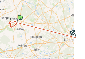

Length
40 km

Max alt
123 m

Uphill gradient
320 m
Km-Effort
44 km

Min alt
87 m

Downhill gradient
314 m
Boucle
No
Creation date :
2025-05-06 06:14:02.279
Updated on :
2025-05-06 09:54:23.527
3h33
Difficulty : Difficult

FREE GPS app for hiking
 SityTrail
IGN / Geographical institutes
SityTrail Plus
The world is yours!
About
Trail Walking of 40 km to be discovered at Centre-Loire Valley, Loir-et-Cher, Le Controis-en-Sologne. This trail is proposed by mimilolo.
Description
départ parking ancien super u
Positioning
Country:
France
Region :
Centre-Loire Valley
Department/Province :
Loir-et-Cher
Municipality :
Le Controis-en-Sologne
Location:
Unknown
Start:(Dec)
Start:(UTM)
381217 ; 5252845 (31T) N.
Comments